
Question 201· Latitude, longitude and time· JAMB
All subjects
JAMB and WAEC Geography questions
614 questions with answers and explanations. Tap an option to check yourself.
All topicsAgriculture, industry and trade · 42Environmental resources and hazards · 33Geography of Nigeria · 42Landforms, weathering and erosion · 52Latitude, longitude and time · 36Map reading: scale, direction and distance · 49Population · 37Relief, contours and gradient · 35Rocks and minerals · 36Settlement · 33The earth in the solar system · 36Transport and communication networks · 29Vegetation and soils · 36Weather and climate · 51West Africa and ECOWAS · 33World regional geography · 34
- Explanation and discussion
Question 202· Latitude, longitude and time· JAMB
The distance between two places on the equator 10° of longitude apart is about
Explanation and discussionQuestion 203· Latitude, longitude and time· WAEC
A traveller crossing the International Date Line from west to east (Asia to America) should
Explanation and discussionQuestion 204· Latitude, longitude and time· WAEC
Lines drawn on a map joining places of equal latitude are
Explanation and discussionQuestion 205· Latitude, longitude and time· WAEC
Two places are 30° of longitude apart. The difference in their local times is
Explanation and discussionQuestion 206· Map reading: scale, direction and distance· JAMB
Grid references give the easting first, which is read
Explanation and discussionQuestion 207· Map reading: scale, direction and distance· JAMB
A map scale of 1:50,000 means that 1 cm on the map represents
Explanation and discussionQuestion 208· Map reading: scale, direction and distance· WAEC
A scale of 1:50,000 means that 1 cm on the map represents
Explanation and discussionQuestion 209· Map reading: scale, direction and distance· JAMB
A rectangle 2 cm by 3 cm on a map of scale 1:50,000 represents a ground area of
Explanation and discussionQuestion 210· Map reading: scale, direction and distance· WAEC
Two places are 7.5 cm apart on a map of scale 1:50,000. The ground distance is
Explanation and discussionQuestion 211· Map reading: scale, direction and distance· WAEC
A distance of 4.5 km on the ground is shown as 9 cm on a map. What is the scale?
Explanation and discussionQuestion 212· Map reading: scale, direction and distance· WAEC
On a map of scale 1:20,000, an area of 4 cm² represents
Explanation and discussionQuestion 213· Map reading: scale, direction and distance· WAEC
On a map of scale 1:25,000, 4 cm represents
Explanation and discussionQuestion 214· Map reading: scale, direction and distance· JAMB
A map area of 4 cm² on a scale of 1:50,000 represents a ground area of
Explanation and discussionQuestion 215· Map reading: scale, direction and distance· WAEC
The angle between true north and magnetic north is called
Explanation and discussionQuestion 216· Map reading: scale, direction and distance· JAMB
The bearing of B from A is 315°. In which direction does B lie from A?
Explanation and discussionQuestion 217· Map reading: scale, direction and distance· JAMB
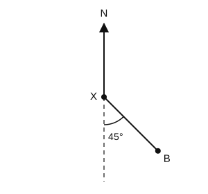
In the diagram, what is the bearing of B from X?
Explanation and discussionQuestion 218· Map reading: scale, direction and distance· JAMB
A road measures 7.5 cm on a map of scale 1:40,000. What is its length on the ground?
Explanation and discussionQuestion 219· Map reading: scale, direction and distance· WAEC
A representative fraction of 1:100,000 means 1 cm on the map represents
Explanation and discussionQuestion 220· Map reading: scale, direction and distance· WAEC
On a map of scale 1:100,000, a road measures 7.5 cm. Its length on the ground is
Explanation and discussion
Practise Geography like the real exam. A timed CBT, your score, and the topics to fix.
Start a Geography test