
Question 101· Latitude, longitude and time· JAMB
All subjects
JAMB Geography questions
318 questions with answers and explanations. Tap an option to check yourself.
All topicsAgriculture, industry and trade · 23Environmental resources and hazards · 17Geography of Nigeria · 22Landforms, weathering and erosion · 28Latitude, longitude and time · 19Map reading: scale, direction and distance · 24Population · 19Relief, contours and gradient · 18Rocks and minerals · 18Settlement · 16The earth in the solar system · 19Transport and communication networks · 14Vegetation and soils · 18Weather and climate · 27West Africa and ECOWAS · 17World regional geography · 19
- Explanation and discussion
Question 102· Latitude, longitude and time· JAMB
A ship crossing the International Date Line from west to east
Explanation and discussionQuestion 103· Latitude, longitude and time· JAMB
Two towns have a difference in local time of 3 hours. The difference in their longitudes is
Explanation and discussionQuestion 104· Latitude, longitude and time· JAMB
Nigeria's time zone, West Africa Time, is
Explanation and discussionQuestion 105· Latitude, longitude and time· JAMB
Places on the same line of latitude have the same
Explanation and discussionQuestion 106· Latitude, longitude and time· JAMB
When it is 12 noon at Greenwich (0°), the local time at a place on longitude 45°E is
Explanation and discussionQuestion 107· Latitude, longitude and time· JAMB
On 21 December, the midday sun is overhead at the
Explanation and discussionQuestion 108· Latitude, longitude and time· JAMB
The Arctic Circle lies at latitude
Explanation and discussionQuestion 109· Latitude, longitude and time· JAMB
The distance between two places on the equator 10° of longitude apart is about
Explanation and discussionQuestion 110· Map reading: scale, direction and distance· JAMB
Grid references give the easting first, which is read
Explanation and discussionQuestion 111· Map reading: scale, direction and distance· JAMB
A map scale of 1:50,000 means that 1 cm on the map represents
Explanation and discussionQuestion 112· Map reading: scale, direction and distance· JAMB
A rectangle 2 cm by 3 cm on a map of scale 1:50,000 represents a ground area of
Explanation and discussionQuestion 113· Map reading: scale, direction and distance· JAMB
A map area of 4 cm² on a scale of 1:50,000 represents a ground area of
Explanation and discussionQuestion 114· Map reading: scale, direction and distance· JAMB
The bearing of B from A is 315°. In which direction does B lie from A?
Explanation and discussionQuestion 115· Map reading: scale, direction and distance· JAMB
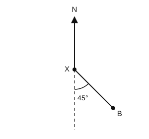
In the diagram, what is the bearing of B from X?
Explanation and discussionQuestion 116· Map reading: scale, direction and distance· JAMB
A road measures 7.5 cm on a map of scale 1:40,000. What is its length on the ground?
Explanation and discussionQuestion 117· Map reading: scale, direction and distance· JAMB
On topographical maps, a trigonometrical station is usually shown by
Explanation and discussionQuestion 118· Map reading: scale, direction and distance· JAMB
Relief on topographical maps may be shown by contours, spot heights and
Explanation and discussionQuestion 119· Map reading: scale, direction and distance· JAMB
A trigonometrical station on a map indicates
Explanation and discussionQuestion 120· Map reading: scale, direction and distance· JAMB
The bearing of due west from a point is
Explanation and discussion
Practise Geography like the real exam. A timed CBT, your score, and the topics to fix.
Start a Geography test